According to the U.S. Department of Transportation, the average American driver covers 13,476 miles a year in his/her vehicle. Thankfully, this great country has a great system of 4.09 million miles of roadways across all 50 states, including 175,000 miles of highways or major roads in the National Highway System.
Federal Highway Administration
How Many Miles Of Road In the U.S
As author and playwright Mehmet Murat Ildan said, “The road may be beautiful or ugly; it may be easy or hard, smooth, or rough, it doesn’t matter. What matters most is where the road will take you.”
Roadways are essential to our national culture, work-life, and freedom to travel. Along those 13,476 miles are many indicators designed to guide and help travelers. Roadway signs use symbols, colors, and shapes to quickly convey information. These are categorized as:
- Regulatory
- Warning
- Guide signs, including street name, route marking, expressway, informational, recreation, and cultural interest signs.
- Emergency management
- Temporary traffic control, such as construction or work zone signs.
- School
- Railroad and light rail
- Bicycle
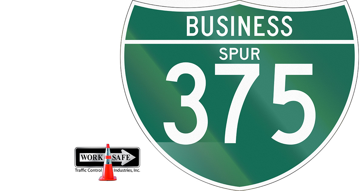
What does ‘Spur’ Mean on Highway Signs?
The term ‘spur’ or ‘spur route’ refers to a short roadway that forms a branch from a longer and more important road such as a major roadway or Interstate Highway. A bypass or beltway is not considered one because it reconnects with the major roadway. Spurs (and loops) are considered auxiliary routes.
Typically, many Interstate Highways have these routes when they enter a large metropolitan area.
How Did They Get This Name?
The term ‘spurs’ is in common use. It refers to a projection from a mountain or mountain range. In medicine, a bone spur is a small pointed bony outgrowth that can be found on the heel, knee, spine, and hip. It is also a metal tool (a common accessory) worn on the back of a horse rider’s boots and used to move a horse forward or to the side while riding. Each of these uses of the term ‘spur’ conveys a pointed departure from the main subject—appropriate to the image of the route.
In Tennessee, “The Spur” is a road that connects Pigeon Forge to Gatlinburg, cutting through the Great Smoky Mountains National Park.
How are These Roads Numbered?
Highways in the United States generally fall into three categories for numbering purposes:
- S. Highways numbered by a system established by the federal government in 1926.
- Interstate Highways established in the Federal Aid Act of 1956.
- Regional roads numbered by individual states.
The routes and route numbers are coordinated by the American Association of State Highway and Transportation Officials (AASHTO) along with the involvement of the United States Department of Transportation.
Major Interstate Freeways in the contiguous United States generally have one or two-digit numbers with odd numbers running south to north; the highest numbers at the south increasing to the north. Interstate Freeway even numbers run west to east with the lowest numbers in the west. Thus, I-5 runs along the West Coast and I-95 runs along the east coast.
101 S. Highways have a similar numbering system but the numerical direction is opposite to that used with Interstates; even numbers are used for roadways running east to west with the lowest numbers in the east and the highest numbers in the west. Roadways running from north to south generally have odd numbers with the lowest numbers in the north and the highest numbers in the south. For example, U.S. Route 1 follows the Atlantic Coast and U.S. Route 101 follows the Pacific Coast. I-5 is the North to South Interstate in the west, running parallel to U. S. Route 101. I-95 is the Interstate Highway along the east coast.
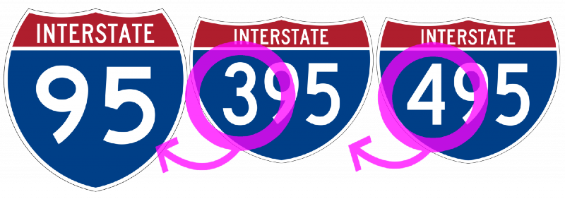
In general, U.S. Routes are older roads that have been superseded by the newer Interstate Highway System.
With some exceptions, these routes have a three-digit designation showing that they are routes off a related parent roadway, for example, U.S. Route 264 would be a branch (‘spur’) off U.S. Route 64.
States and counties sometimes use different signage to designate regional state and county roads, but generally, signage across the country follows the U. S. Interstate numbering system.
United States Numbered Highway System
Concluding Thoughts
Local governments use professional signage to guide travelers and to help ensure an excellent roadway safety record. Many local government entities turn to Worksafe Traffic Control Industries, based in Barre, VT to provide the highest quality on every order. All our products are MUTCD-certified and compliant.
As a women-owned business, Worksafe Traffic Control Industries is a highly regarded manufacturer of construction, roadway and commercial signs and a distributor of traffic control products and devices. We have a state-of-the-art fleet of traffic control equipment and offer state of the art technology solutions for highways, construction zones, traffic calming, and incident management applications. Worksafe offers a 7-day turnaround on orders and we are very competitive as a business and government contractor.